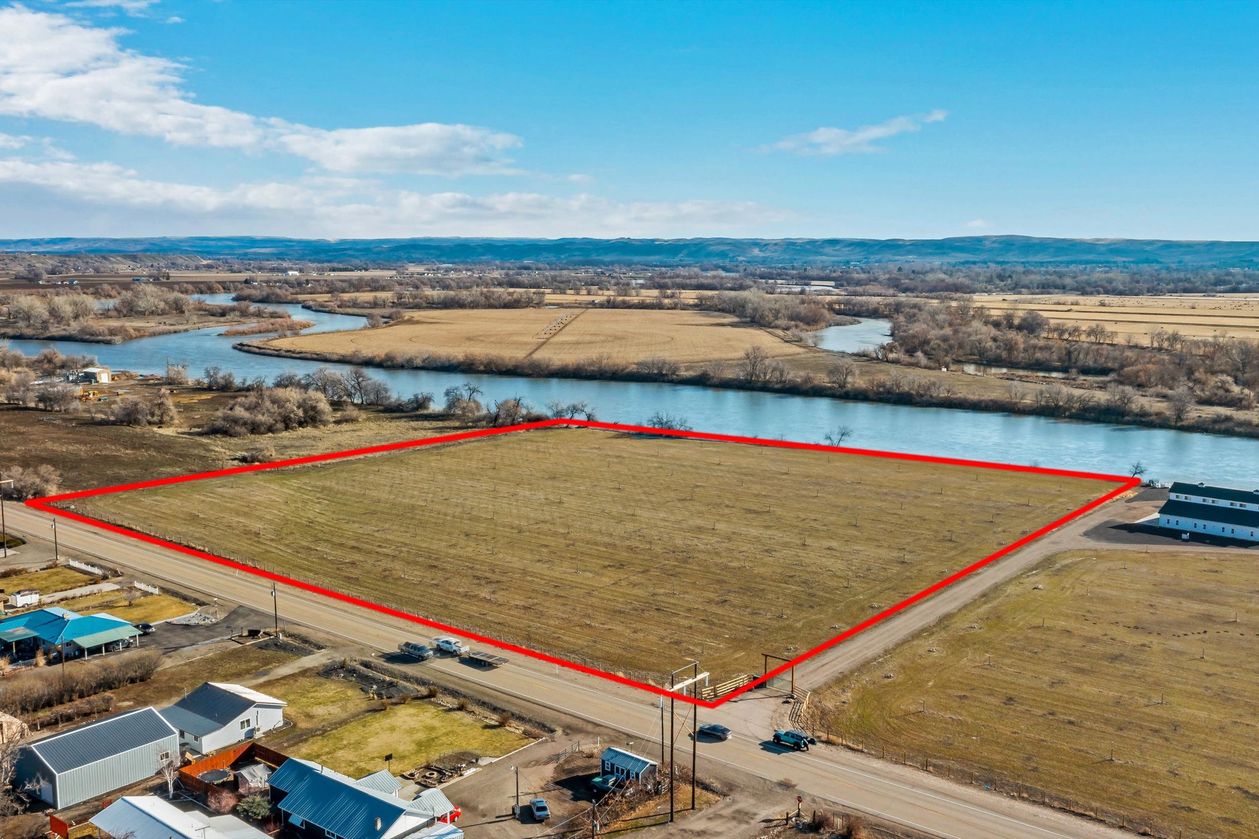
Waterfront lot with owner financing situated along the Snake River with picturesque views of Banks Island and the potential to build. The level topography, year-round access, and power availability make this property an ideal setting to build your dream home. The land comes with a solid set sprinkler system, making it perfect for irrigation and farming. Currently, the acreage is utilized for growing alfalfa crops which could continue to provide a source of income for the future owner. The land also includes 6 water right acres through Owyhee Irrigation. Access to the lot from the highway is on the north end of the parcel. Additionally, it is conveniently located close to town, offering easy access to amenities and services while still providing a peaceful rural setting. The owner will carry a loan with a minimum of 30% down for 5 years at a 5% interest rate. Alfalfa Crop Building Permit Close to Town Irrigated Level Topography Owner Carry Option Power Available Riverfront Water Rights Year Round Access A current conditional use permit for 1 single-family dwelling is in place which expires in September 2024. The entire property, with the exception of a small portion of 0.6 acres is within the floodplain, so if any development will occur on the portion that is in the floodplain, the owner will have to comply with FEMA's floodplain requirements. If you have a passion for fishing or water-based recreational activities, this property is perfect for you as it is located right on the banks of the Snake River.The land is in the Beulah hunting unit 65 where there are opportunities to hunt deer, elk, pronghorns, bighorn sheep, and black bears. You are also centrally located to several state parks, wildlife management areas, and recreational sites. 0 miles from the Snake River 2.2 miles from Interstate 84 2.5 miles from Ontario State Recreation Site 4.2 miles from Ontario 3.9 miles from Malheur County Fairgrounds 6.7 miles from Scotch Pines Golf Course 6.9 miles from Payette Greenbelt Pond 15.8 miles from Payette River Wildlife Management Area 22.3 miles from Fort Boise Wildlife Management Area 47.1 miles from Lake Owyhee State Park The land also includes 6 water right acres through Owyhee Irrigation. The 2023 irrigation assessment is $450 ($75 per acre ). No transfer or administrative fees apply. The property is just off of Olds Ferry -Ontario Highway 201 on the outskirts of Ontario, Oregon.Ontario is an agricultural community that lies along the Oregon-Idaho border overlooking the Snake River. The area is known for its prime agricultural growing land which commonly produces crops such as russet potatoes, sugar beets, and onions. Its location is unique in that it is near the point where four major rivers converge. These rivers are the Snake, the Malheur, the Owyhee, and the Payette rivers. Besides the robust agricultural economy, Ontario offers its residents several local events and cultural opportunities. Local attractions includeThe Four Rivers Cultural Center, theAnnual Great Owyhee Ride, andMalheur County Fair. Ontario is also close to some beautiful natural attractions such as Malheur Butte, the Owyhee Reservoir, and Leslie Gulch. Ontario is also on the eastern edge of theTreasure Valley, which encompasses the Boise metro area and is a mere one-hour drive from Boise, Idaho.

 ;
; ;
; ;
; ;
; ;
; ;
; ;
; ;
; ;
;